The Ultimate Mountain Weather App for UK Mountain Enthusiasts
Mountain Weather UK (MWUK) is the ultimate mobile phone mountain weather app dedicated to providing weather forecasts, observations and maps for all UK mountain regions.
Whether you are Climbing, Walking, Skiing or Mountain Biking Mountain Weather UK makes it easy for you to access all this information at your fingertips from your mobile phone.
Making Mountain Weather Smarter
Download FREE and start your 14‑day Pro trial to unlock all the features.

v2.1.0 Major Update
Mountain Weather UK v2.1.0 is now available.This a major new update integrating the Hill Bagging Database of British and Irish Hills (DoBIH), expanding coverage to over 11,500 peaks and 37 Mountain and upland regions across the UK and Ireland.
37 mountain and upland regions now span the UK, Isle of Man and the Republic of Ireland, including new regions such as the Southern Pennines, Forest of Bowland, Outer Hebrides, Orkney and Shetland, Isle of Man, and every upland region in Ireland.
Every summit now carries its hill-bagging classification - Munro, Wainwright, Corbett, Hewitt and more, with colour-coded pins on the map, classification filters in the summit list, and sort by height or classification.
The summit map is redesigned with intelligent pin clustering, parent mountain names on each top, and OS Topo contour lines for Pro subscribers. Includes smarter mountain search, searching for a mountain name finds all associated tops and subsidiary summits.
Forecasts now load progressively, loading core data first and summaries loading independently — so you see useful information faster.
About MWUK
Mountain Weather UK (MWUK) is the ultimate mobile phone mountain weather app, dedicated to providing forecasts, observations and maps for all UK mountain regions. Whether you are climbing, walking, skiing or mountain biking, MWUK puts essential weather information at your fingertips — clear, hazard‑first summaries to help you plan and stay safe.
MWUK combines regional forecasts, summit interpolation and station observations with synoptic charts in a compact, readable format designed for decisions on the hill. The app is built by hill users for hill users and continues to evolve based on user feedback and data sources.
MWUK v2 is now released
Mountain Weather UK has been completely rebuilt from the ground up. Version 2 brings faster data ingestion, improved elevation‑aware forecasting and clearer hazard‑first summaries so you can make quick, safe decisions on the hill.
Under the new architecture MWUK uses a dedicated server API to produce regional and summit forecasts with better reliability. You’ll notice faster loading, cleaner daily cards and improved hour detail, all designed to make critical weather information simpler to read when it matters most.
What’s new in v2:
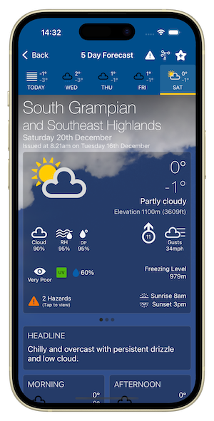
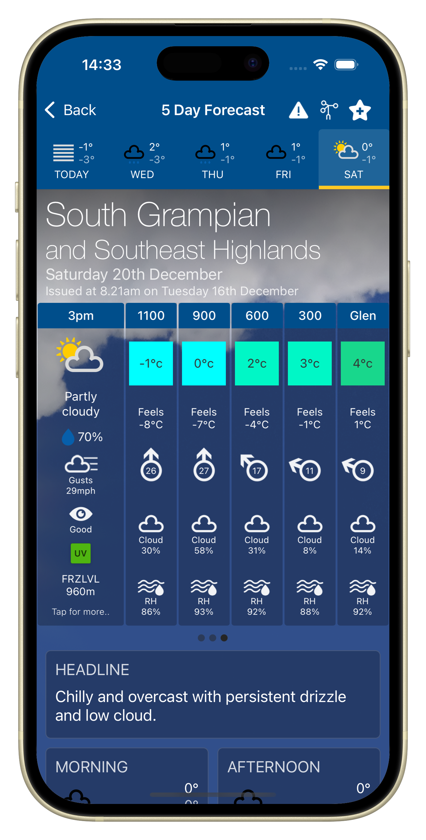
- Full 5 Day Regional and Mountain Summit forecasts
- Mountain Area Map showing each region so you can visualise and select whole mountain areas quickly.
- AI Assisted Headline and Weather Summaries, Meteorologist's View & Hill Walker Advice
- Pressure & Fronts card showing Pressure Tendency and Frontal signals.
- 3 hourly and elevation forecasts.
- Hazards detailing Hazard Types, description and likelihood for each day.
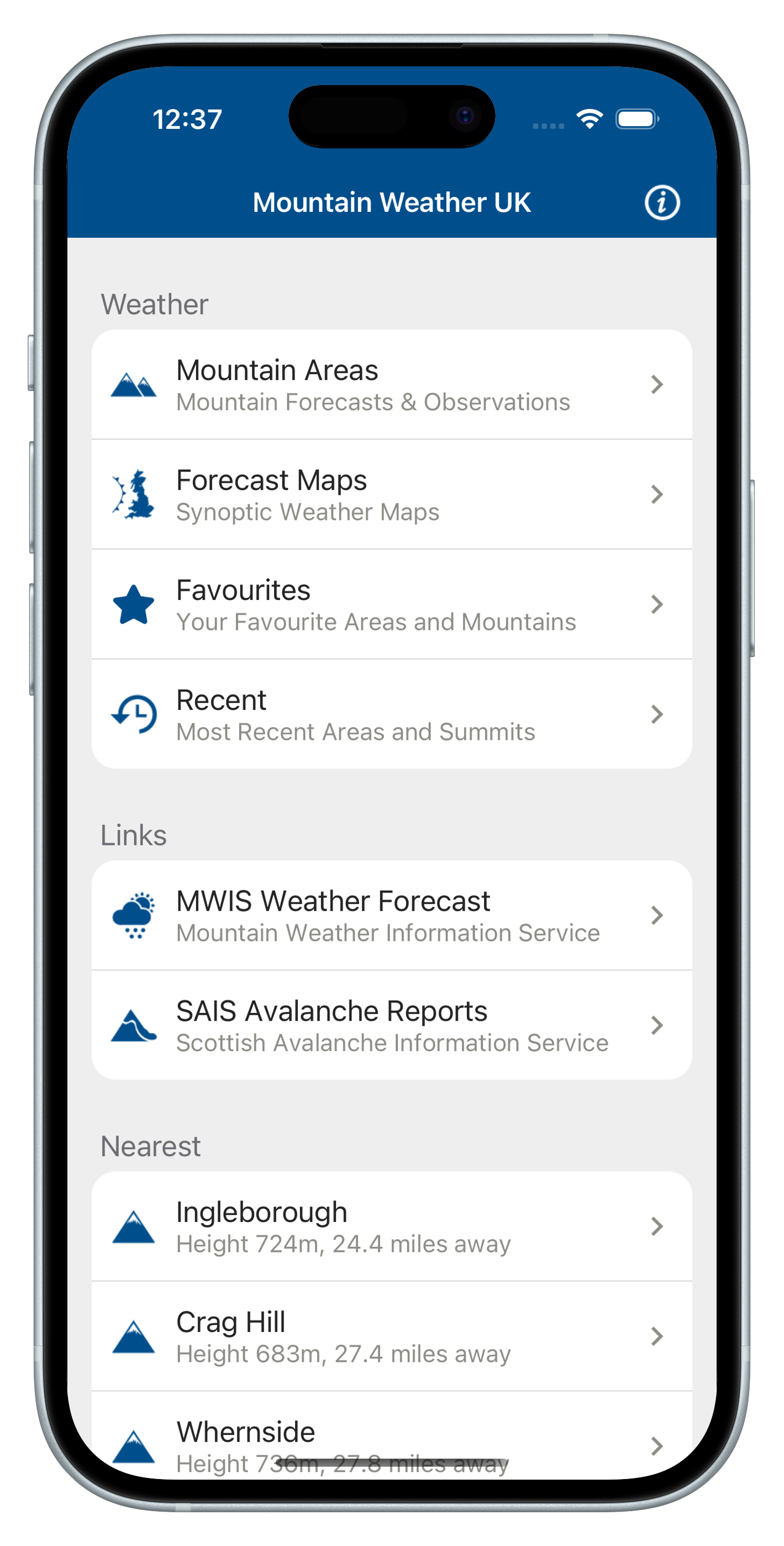
- Favourite Regions, Mountains & Weather Stations
- Recent visited Regions, Mountains & Weather Stations
- Nearest 3 Mountains and Region to your current location
Download FREE and get 14-day Pro trial
Download Mountain Weather UK free from the App Store and try Pro free for 14 days. The trial gives you full access to extended forecasts and advanced tools so you can see how extra detail helps with planning.
Pro highlights include the full 5‑day forecast window (days 3–5), elevation breakdowns from valley to summit, extended 3‑hour afternoon periods and expert text cards such as Meteorologist’s View and Hill Walker Advice.
Pro also adds a Pressure & Fronts card showing pressure tendency and frontal signals, a Hazards screen detailing hazards and likelihoods, and the ability to add regions and mountains to Favourites directly from forecast pages.
Key features
Forecasts
Full 5 day regional and mountain summit forecasts for all 19 mountain regions in the UK.
- Providing main weather summary of weather type, max/min temp, elevation, cloud cover, Relative Humidity, Dew Point, Wind Speed & Direction, Wind Gusts, Visibility, UV, Precipitation Probability, Freezing Level, Hazards, Sunrise/sunset
- Weather summary text cards for: Headline, Morning / Afternoon weather, Weather Summary, Meteorologist's View, Hill Walker Advice, Pressure & Fronts, Temperature at 900m, Low Level Temperature, Max Wind Above 900m, Visibility & Hill Cloud at 900m
- 3 hourly forecast periods and elevation forecasts showing Weather Type, Precipitation Probability, Wind Gusts, Visibility, UV & Freezing Level.
Observations
Weather Station observations for all mountain regions providing Hourly weather station observation charts for Temperature, Wind Speed, Wind Gusts, Wind Direction, Visibility, Humidity, Pressure Tendency and Surface Pressure.
Forecast Maps
48 hour Synoptic Weather Forecast Maps for Rainfall / Cloud Cover / Temperature and Pressure