The Ultimate Mountain Weather App for UK Mountain Enthusiasts
Mountain Weather UK (MWUK) is the ultimate mobile phone mountain weather app dedicated to providing weather forecasts, observations and maps for all UK mountain regions.
Whether you are Climbing, Walking, Skiing or Mountain Biking Mountain Weather UK makes it easy for you to access all this information at your fingertips from your mobile phone.
Making Mountain Weather Smarter
Download FREE and start your 14‑day Pro trial to unlock all the features.

New Weather Visuals Interactive Preview!
We are very excited to share with you an interactive preview of a new suite of weather visualizations that will be available in the next release of the Mountain Weather UK App.
Using the latest modern technology to bring you beautiful mountain weather visualizations, including wind, pressure, temperature, precipitation, freezing level, cloud cover, sun and UV, all rendered as interactive, hour-by-hour UK Synoptic map, and regional & summit weather map visualizations. This takes mountain weather forecasting to the next level.
This web version preview features some of the new visualizations that will be available in the next release of the Mountain Weather UK App.
The Synoptic Weather Visuals bring the forecast to life with interactive, real-time maps of the UK and Ireland. See wind flows animated across the landscape, precipitation types (rain, snow, sleet and thunder) plotted by location, temperature, atmospheric pressure gradients & animated isobars, freezing levels, cloud layers from valley fog to high cirrus, and sunshine duration with UV index - all beautifully presented.
Regional visualizations put the bigger picture in context. View regional weather visualizations for all 37 regions across the UK & Ireland so you can access the weather forecast by mountain region. In this preview we provide 3 regions.
Summit specific three-dimensional isometric weather visualizations render the actual terrain around that summit, with the forecast wind data drawn directly on top of it. Plus a mountain elevation profile showing freezing level and cloud cover, and a unique 3D wind terrain view.
Introducing New Weather Animations in v2.2
The Mountain Weather UK App v2.2 has now been released! This version includes new beautiful Mountain Weather Animations on the forecast page.
The animations use the weather data to produce animations based on the weather type, cloud cover, wind speed and direction. These are translated into weather animations using a physics engine to create the clouds and precipitation.
These are entirely optional and you can turn them off if you don't like them and just show the static weather backgrounds. Or you will also be able to turn both off and just have a plain background.
About MWUK
Mountain Weather UK (MWUK) is the ultimate mobile phone mountain weather app, dedicated to providing forecasts, observations and maps for all UK mountain regions. Whether you are climbing, walking, skiing or mountain biking, MWUK puts essential weather information at your fingertips — clear, hazard‑first summaries to help you plan and stay safe.
MWUK combines regional forecasts, summit interpolation and station observations with synoptic charts in a compact, readable format designed for decisions on the hill. The app is built by hill users for hill users and continues to evolve based on user feedback and data sources.
MWUK v2 is now released
Mountain Weather UK has been completely rebuilt from the ground up. Version 2 brings faster data ingestion, improved elevation‑aware forecasting and clearer hazard‑first summaries so you can make quick, safe decisions on the hill.
Under the new architecture MWUK uses a dedicated server API to produce regional and summit forecasts with better reliability. You’ll notice faster loading, cleaner daily cards and improved hour detail, all designed to make critical weather information simpler to read when it matters most.
What’s new in v2:
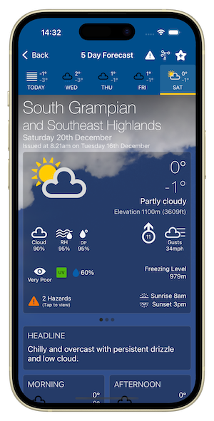
- Full 5 Day Regional and Mountain Summit forecasts
- Mountain Area Map showing each region so you can visualise and select whole mountain areas quickly.
- Weather Summaries including Headline, Weather, Meteorologist's View,Pressure & Fronts, Temperature at 900m, Low Level Temperature, Max Wind at summit, Visibility & Hill Cloud at summit.
- Pressure & Fronts card showing Pressure Tendency and Frontal signals.
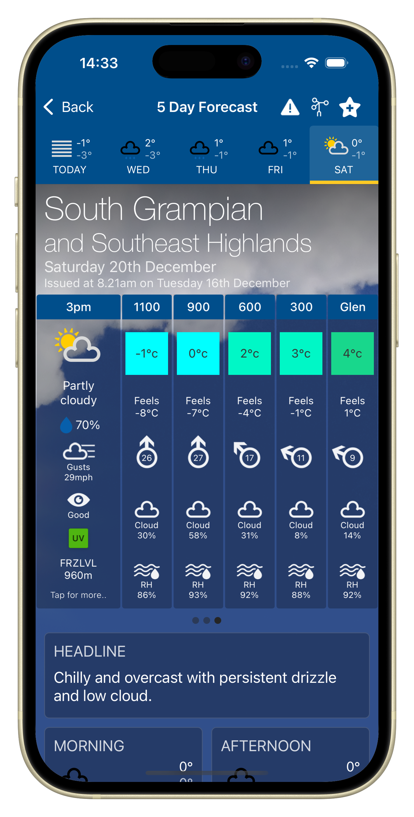
- 3 hourly and elevation forecasts.
- Hazards detailing Hazard Types, description and likelihood for each day.
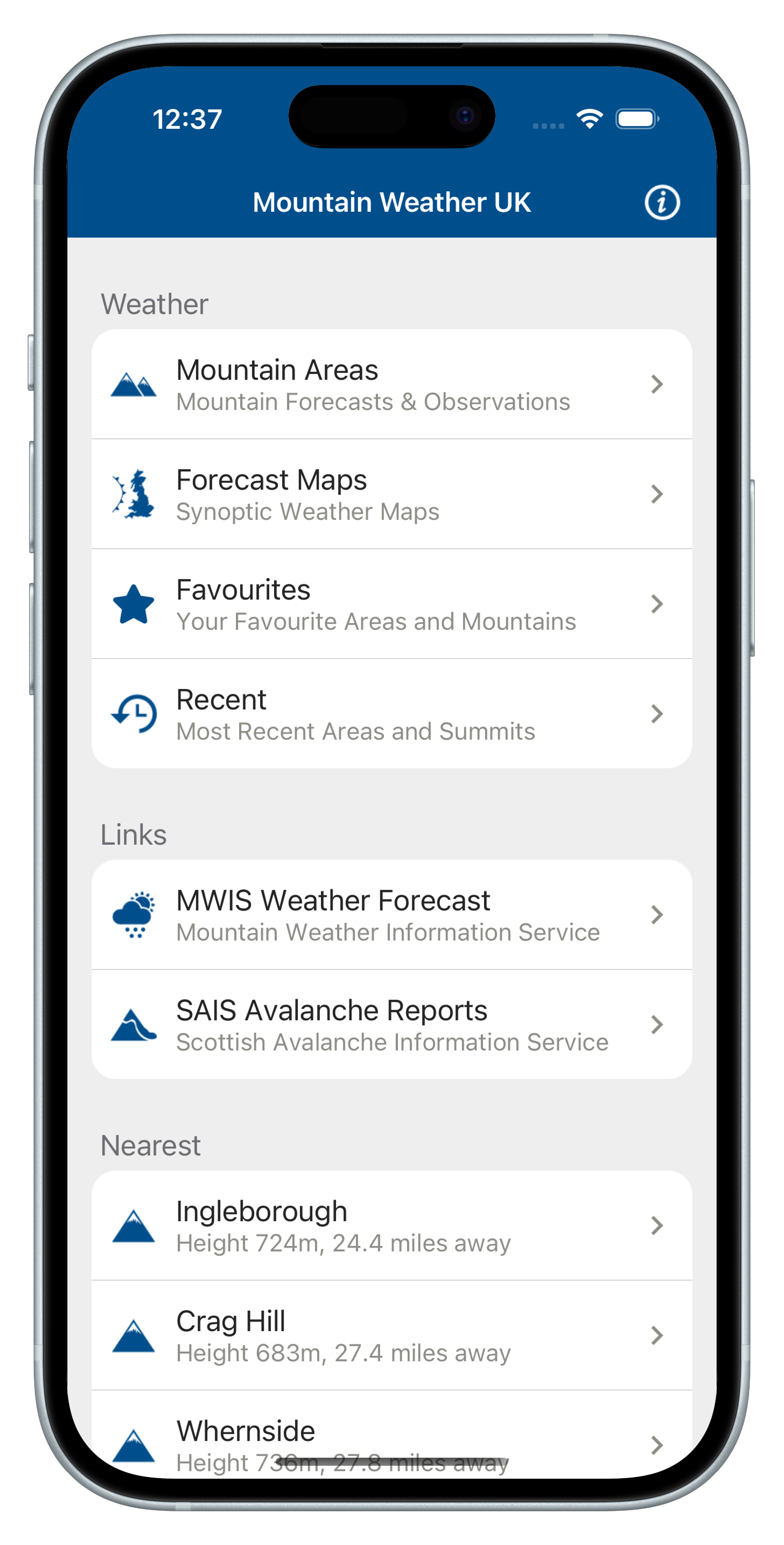
- Favourite Regions, Mountains & Weather Stations
- Recent visited Regions, Mountains & Weather Stations
- Nearest 3 Mountains and Region to your current location
Download FREE and get 14-day Pro trial
Download Mountain Weather UK free from the App Store and try Pro free for 14 days. The trial gives you full access to extended forecasts plus extra features.
- Extended 2-5 day regional and summit forecasts.
- Detailed 3 hourly and elevation breakdowns.
- Weather Station Observations including Temperature, Wind & Wind Gusts, Visibility & Pressure
- 48 hour Synoptic Maps including Rainfall, Cloud, Temperature & Pressure
- Ordinance Survey Summit Maps
Key features
Forecasts
Full 5 day regional and mountain summit forecasts for all 19 mountain regions in the UK.
- Providing main weather summary of weather type, max/min temp, elevation, cloud cover, Relative Humidity, Dew Point, Wind Speed & Direction, Wind Gusts, Cloud Cover, Cloud Base Visibility, UV, Precipitation Probability, Freezing Level, Hazards, Sunrise/sunset
- Weather summary text cards for: Headline, Morning / Afternoon weather, Weather Summary, Meteorologist's View, Pressure & Fronts, Temperature at 900m, Low Level Temperature, Max Wind Above 900m, Visibility & Hill Cloud at 900m
- 3 hourly forecast periods and elevation forecasts showing Weather Type, Precipitation Probability, Wind Gusts, Visibility, UV & Freezing Level.
- Weather Station observations for all mountain regions providing Hourly weather station observation charts for Temperature, Wind Speed, Wind Gusts, Wind Direction, Visibility, Humidity, Pressure Tendency and Surface Pressure.
Observations
Weather Station observations for all mountain regions providing Hourly weather station observation charts for Temperature, Wind Speed, Wind Gusts, Wind Direction, Visibility, Humidity, Pressure Tendency and Surface Pressure.
Forecast Maps
48 hour Synoptic Weather Forecast Maps for Rainfall / Cloud Cover / Temperature and Pressure